-
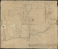
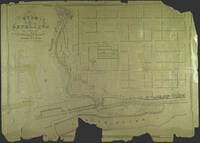
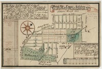 [Town map of Emmaus, Pennsylvania, 1760]
 Full Title: Grund-Riß von Emaus in Salisbury und dem dazu gehörigen Lande so wie daßelbe in Lots eingetheilet worden im Februar 1760; A manuscript map drawn by a surveyor from the Moravian community
-
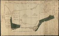 [Plan of the Farmlands west of Bethlehem, 1786]
 Full title: Grund Riß des zur Farm gehörigen Landes auf der West Seite von Bethlehem [Plan of the farmlands on the west side of Bethlehem, north of the Lehigh River, west of the Monocacy Creek] A manuscript map drawn by a surveyor from the Moravian community.
-
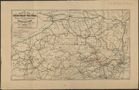
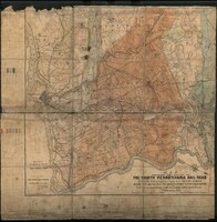 A Map of the North Pennsylvania RR to Bethlehem
 Full Title: Map shewing the Route of the North Pennsylvania Rail Road from Philadelphia to Bethlehem with its Branches to Doylestown and Freemansburg and its connections with the Lehigh Valley Rail Road
-
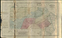 An Historical Map of Pennsylvania 1875
 Full title: An Historical Map of Pennsylvania showing the Indian names of Streams and Villages, and Paths of Travel; The Sites of Old Forts and Battle Fields; The Successive Purchases from the Indians; and the Names and Dates of Counties and County Towns, with Tables of Forts and Proprietary Manors
-
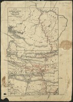
 Map of the Lehigh Valley Rail Road Penna & N.Y. Canal & Rail Road and Connecting Lines Map of the Lehigh Valley Rail road from New York to Lake Erie
 Map of the connections for passenger trains of the Lehigh Valley Railroad
-
 Map of the Lehigh Valley Rail Road and Connections
 Map of the connections for passenger trains of the Lehigh Valley Railroad
-
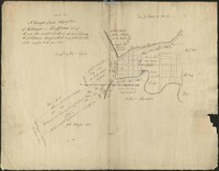 Plan for the future town of Easton, Pennsylvania
 A cadastral map showing land parcels for sale in Easton. William Parsons was an agent for the Penns, acting for them during, and after the establishment of Easton in 1752. Note that the map is oriented with South at the top.
-
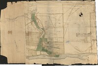 Town map of Bethlehem and vicinity
 A pen and watercolor-on-paper map of Bethlehem, its surrounding farm lands, and adjacent properties.
-
 Map of land holdings along the Lehigh River
 A pen-on-paper, linen-backed, map of the land holdings from modern-day Northampton to Easton.
-
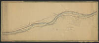
 Map No. 9. Lower Division. Location of the Extension of the Lehigh and Susquehanna Rail Road.
 From a series of 9 maps, detailing the Lehigh and Susquehanna Railroad running alongside the Lehigh River from Mauch Chunk to Easton. These maps also include surveying information on local landowners, towns, and cities.
-
 Map No. 8. Lower Division. Location of the Extension of the Lehigh and Susquehanna Rail Road.
 From a series of 9 maps, detailing the Lehigh and Susquehanna Railroad running alongside the Lehigh River from Mauch Chunk to Easton. These maps also include surveying information on local landowners, towns, and cities.
-
 Map No. 7. Lower Division. Location of the Extension of the Lehigh and Susquehanna Rail Road.
 From a series of 9 maps, detailing the Lehigh and Susquehanna Railroad running alongside the Lehigh River from Mauch Chunk to Easton. These maps also include surveying information on local landowners, towns, and cities.
-
 Map No. 6. Lower Division. Location of the Extension of the Lehigh and Susquehanna Rail Road.
 From a series of 9 maps, detailing the Lehigh and Susquehanna Railroad running alongside the Lehigh River from Mauch Chunk to Easton. These maps also include surveying information on local landowners, towns, and cities.
-
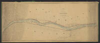
 Map No. 5. Lower Division. Location of the Extension of the Lehigh and Susquehanna Rail Road.
 From a series of 9 maps, detailing the Lehigh and Susquehanna Railroad running alongside the Lehigh River from Mauch Chunk to Easton. These maps also include surveying information on local landowners, towns, and cities.
-
 Map No. 4. Lower Division. Location of the Extension of the Lehigh and Susquehanna Rail Road.
 From a series of 9 maps, detailing the Lehigh and Susquehanna Railroad running alongside the Lehigh River from Mauch Chunk to Easton. These maps also include surveying information on local landowners, towns, and cities.
-
 Map No. 3. Lower Division. Location of the Extension of the Lehigh and Susquehanna Rail Road.
 From a series of 9 maps, detailing the Lehigh and Susquehanna Railroad running alongside the Lehigh River from Mauch Chunk to Easton. These maps also include surveying information on local landowners, towns, and cities.
-
 Map No. 2. Lower Division. Location of the Extension of the Lehigh and Susquehanna Rail Road.
 From a series of 9 maps, detailing the Lehigh and Susquehanna Railroad running alongside the Lehigh River from Mauch Chunk to Easton. These maps also include surveying information on local landowners, towns, and cities.
-
 Map No. 1. Lower Division. Location of the Extension of the Lehigh and Susquehanna Rail Road.
 From a series of 9 maps, detailing the Lehigh and Susquehanna Railroad running alongside the Lehigh River from Mauch Chunk to Easton. These maps also include surveying information on local landowners, towns, and cities.
-
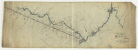 Map Showing Lehigh Division Canal, Mauch Chunk to Easton : Also Diagram Showing Lifts of Locks and Lengths of Levels
 This map shows the Lehigh Division Canal from Mauch Chunk to Easton.
-
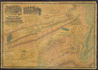 Map of the Borough and Township of Mauch Chunk
 This large map shows a map of the Borough & Township of Mauch Chunk including plans of Nesquehoning, Summit Hill, the borough of Tamaqua, and the coal works of the Lehigh Coal & Navigation Company. Included in the top left corner of the map are two manuscript illustrations depicting the Mansion House of George Esser and the Superintendent's residence.
-
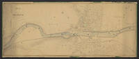
 Map of City of Bethlehem
 A plan of Bethlehem. This lithograph was produced by J. Probst in Philadelphia in 1841, then the leading map publishing center in North America.
-
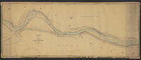
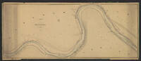
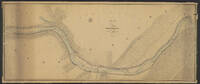
 Chart of the Delaware River
 An engineering survey of the Delaware River made under the direction of the Lehigh Coal and Navigation Company in preparation for canal construction.
-
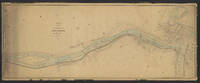
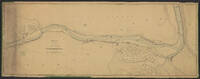
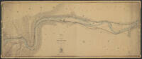
 Allentown to Easton: A Chart of the River Lehigh from Allentown to Easton
 An engineering survey of the Lehigh River from Allentown to Easton made under the direction of the Lehigh Coal and Navigation Company in preparation for canal construction. In the bottom right corner of the map is a table detailing the fall of the river from Mauch Chunk to Easton. Locations of limestone ridges, hills, and nobs are also featured.
-
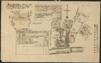 Part of Bethlehem Farms on the South Side of the River Lehy
 A pen and watercolor-on-paper survey map of the farms south of the Lehigh River by Bethlehem.
-
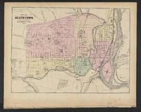 City of Allentown
 From the "New Topographical Atlas of the State of Pennsylvania; with Descriptions Historical, Scientific and Statistical, Together with a Map of the United States and Territories."