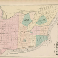
Plan of Easton of 1874 from the Atlas of Northampton County, Pennsylvania, from actual surveys by and under the direction of D. G. Beers.
Item
-
Title
-
Plan of Easton of 1874 from the Atlas of Northampton County, Pennsylvania, from actual surveys by and under the direction of D. G. Beers.
-
Description
-
This is a plan of the city of Easton with a scale of 4.5 rods to an inch. It includes all the street names in the town, Lafayette College, Easton Cemetery, the courthouse, and the Snyder and Stryleer Grist Mill. It's bordered by the Delaware and the Lehigh rivers.
-
Creator
-
Daniel G. Beers
-
Source
-
Lafayette College Special Collections and College Archives
-
Publisher
-
A. Pomeroy & co.
-
Date
-
1874