
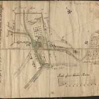
[Map of Gnadenhütten]
Item

- Title
- [Map of Gnadenhütten]
- Date
- 1771
- Description
- Map, created using pen and watercolor on paper, titled "Draught of the Congregation Land at the Mahony Creek the 24th Sept 1771."
- Is Part Of
- Collection of Drawings and Prints
- Spatial Coverage
- Lehighton and Weissport, Carbon County, Pennsylvania
- Provenance
- Moravian Archives, Bethlehem, Pennsylvania
- Item sets
- Historical Maps of the Lehigh Valley
- Site pages
- Digital Map Collections
- Media
 [Map of Gnadenhütten]