-
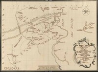
 [Draft Survey of Delaware River from Easton to Head of Tide]
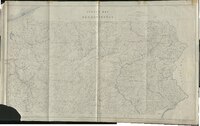
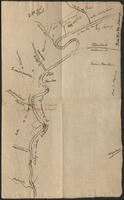
 A manuscript map produced for the Lehigh Coal and Navigation Company for developing a canal to transport anthracite coal from Mauch Chunk to Philadelphia along the Lehigh and Delaware Rivers. This is a draft map made by Surveyor Issac Chapman for the production of the LCNC map "A Chart of the River Deleware." Physical features include the river, islands, settlements and channels. Many notes and annotations included in this draft are unique and do not appear in the final printed version of the map. Map image is supplemented with two items of ephemera. These list vertical measurements at key points along the course of the survey.
-
 A Chart of the River Lehigh from Mauch Chunk to Allentown
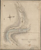
 A map produced for the Lehigh Coal and Navigation Company for developing a canal to transport anthracite coal from Mauch Chunk to Philadelphia along the Lehigh and Delaware Rivers. This map covers one section of the route. Physical features include the river, islands and channels with alluvial plains noted and terrain depicted by hachures. Cultural features include roads, paths, bridges, dams and buildings with ferries, fords and some buildings identified by owner.
-
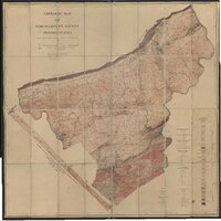
 Map of Lehigh County, Pennsylvania
 Wall map of Lehigh County, Pennsylvania. Along the outer edges of the map are numerous illustrations of notable locations within the county. Includes a chart detailing the 1860 census information for the county and townships, notes on the history of the county, and a table of distances between locations within the county. The map also has multiple inset maps of cities and towns within the county.
-
 Map of Wilkes-Barre, Luzerne Co., Pennsylvania
 Large scale map of the City of Wilkes-Barre. Includes illustrations of the Wyoming Seminary & Commercial College (Kingston, PA). Also an illustration of the Wyoming Valley Hotel. Additional Business Directory of subscribers.
-
 Portion of Map of the Lehigh Navigation from White Haven to Easton
 Topographic map of a short portion of the entire Lehigh Navigation. This section runs from the Penn-Haven railroad junction at the confluence of Black Creek to the Lehigh River to Mauch Chunk. This item is a blueprint map copy dated November 27, 1925. Date of original unknown.
-
 Philadelphia Water Supply Company Proposed Aqueduct Lines
 This map shows the Philadelphia Water Supply Company's proposed aqueduct lines to supply the city of Philadelphia with 250 million gallons per day of filtered water from the Delaware River by gravity and steam pumping.
-
 Map of Property in the Vicinity of Lehigh Gap and Palmerton Station, Lower Towamensing Township, Carbon County, PA.
 This map shows the property in the vicinity of the Lehigh Gap and Palmerton station in Carbon County, along with property owners and several railroads.
-
 Map of the Extension of the Lehigh and Susquehanna Railroad from Penn-Haven to Mauch Chunk: Showing its Connections with Other Railroads
 Surveyed on April 7th, 1863 under the direction of John Leisenring, superintendent and engineer. Copied by E. B. Leisenring, 1865. The map is a copy dated December 13th, 1912.
-
 Map Showing Lehigh Division Canal, Mauch Chunk to Easton
 Topographic map of Lehigh Division Canal. Also a diagram showing lifts of locks and lengths of levels.
-
 Map of Anthracite Coal Fields in Pennsylvania
 Features the southern (first) and middle (second) Pennsylvania anthracite coal fields in Dauphin, Lebanon, Schuylkill, Carbon, Northumberland, and Columbia counties. It details the distances of coal-producing cities to New York and Philadelphia markets and provides an extensive list of anthracite collieries with their respective operators, landowners, and ash type shown at the bottom of the map. This is a copy of the original, photo-lith by A. Dickes, Philadelphia, date unknown.
-
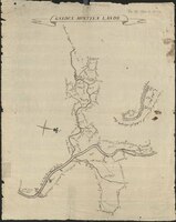
 Map of Lands in Nesquehoning Valley
 This blueprint map shows the lands in the Nesquehoning Valley to be sold by the Panther Valley Water Company to the Lehigh Coal and Navigation Company.
-
 Plan of the Borough of Allentown
 Plan of Allentown, showing streets, buildings, and waterways with perspectives of important buildings along the sides.
-
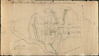
 Map of a proposed development of "West Side" in Bethlehem
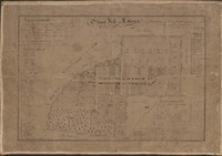
 Pen drawing of a proposed development of "West Side," an area between Sixth Avenue, Spring Street, Tenth Avenue, and Raspberry Street in West Bethlehem, PA.
-
 Genealogical Map of the Counties
 Color print historical map of Pennsylvania showing when the counties were formed.
-
 Stream map of Pennsylvania
 Printed map of Pennsylvania showing major waterways.
-
 [Survey of Gnadenhütten lands]
 Survey of lands along the Lehigh River, in the vicinity of the Moravian mission at Gnadenhütten on the Mahoning Creek.
-
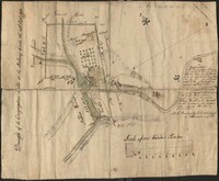 [Map of Gnadenhütten]
 Map, created using pen and watercolor on paper, titled "Draught of the Congregation Land at the Mahony Creek the 24th Sept 1771."
-
 Plan for a road running from Easton Road in Bethlehem to the Berks County line
 Pen and watercolor drawing of a planned road from the Easton road (Easton Avenue) through Bethlehem and Emmaus, Pennsylvania to the Berks County line.
-
 Moravian travel map of eastern Pennsylvania, Maryland, and eastern New Jersey
 Pen and watercolor travel map showing lands, residences, churches, and schoolhouses owned by the Moravian Church, as well as routes of travel, houses where Moravians can shelter overnight, and residences of families connected to the Moravians.
-
 Map of Schoeneck near Nazareth 1761
 Pen and watercolor map showing properties and topography of the new village of Schoeneck near Nazareth.
-
 Geologic map of Northampton County
 Printed map of Northampton County showing mines, quarries and pits, in addition to geological composition using aerial technology.
-
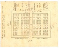 Map of the Moravian cemetery in Allemaengel (Lynn Township)
 Pen-on-paper cemetery map showing the layout of the cemetery of Allemaengel Moravian Church, with references to cardinal diections, the widths and lengths of sections and passageways, and to the ages and genders of persons buried in particular rows. A note on the left-hand side of the map indicates that the fence dimensions around the cemetery were inexact, because no measurements were made when the fence was erected. Date approximate.
-
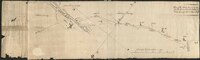
 Map of waterways along the Lehigh River between the Mahoning Creek and Leslie Run
 Pen-on-paper map of waterways along the Lehigh River north of Lehighton (then called Gnadenhütten). Map prepared by a Moravian minister. Date approximate
-
 Map of Mauch Chunk (Jim Thorpe)
 Map of Mauch Chunk (Jim Thorpe) by cartographer Solomon White Roberts (1811-1882), executed as a pen and wash drawing.
-
 Town map of Salisbury (Emmaus) 1839
 Historical map of the town of Emmaus, formerly called "Salisbury," with references to changes in property ownership since the year 1760. The map is attributed to a Moravian minister, Carl Friedrich Seidel (alias Charles Frederick Seidel) based on handwriting analysis, who copied from early maps and created the map as a pen drawing on linen-backed paper.
